
The River West of the Old Town
阅读中文版
In wuxia novels (武侠小说), wherever there are people, there is jianghu (江湖)[1]. In the real world, however, wherever people gather, the jianghu[2] may eventually disappear. This refers to those landscapes erased from physical space to make way for urban development.
Today, more than half of the western side of Kuching’s Bazaar once consisted of a uniquely shaped river known as Sungai Gartak, a tributary of the Sarawak River. In two old maps dated 1870 and 1890, the river can clearly be seen: its upper reaches resembled a lake, followed by a long narrow channel stretching toward the Sarawak River like a neck. Taken as a whole, it looked almost like a standing dinosaur.
Historical records concerning Sungai Gartak are extremely scarce. Only through fragments of surviving material can one piece together memories of a landscape that disappeared more than a century ago.
The name “gartak” is said to derive from Sarawak Malay, meaning a “platform” or “wooden bridge.” A related term is titi, while elsewhere on Borneo similar words such as gertak, geratak, and ghetok carry comparable meanings. As for how the river itself came to bear the name Gartak, one theory suggests the area was once marshy lowland where wooden walkways were necessary for movement. Though this remains unverified, the idea is not without basis.
Compared with the eastern side of old town, the land around Sungai Gartak was indeed lower in elevation. Historical floods frequently affected streets within the old river basin, including India Street, Gambier Street, Carpenter Street, and Market Street. Elderly Kuching residents also recalled that the nearby Jalan Haji Taha area was once swamp land filled with Malay stilt houses linked by wooden walkways. One cannot help but wonder whether the surroundings of Sungai Gartak once looked much the same.
Among the earliest communities living along the riverbanks were South Indian Muslims, who had settled there since at least the 1830s, forming what later became today’s India Street and Gambier Street. Across the Sungai Gartak stood a Javanese settlement which, after the community relocated in the late nineteenth and early twentieth centuries, eventually became present-day Java Street. A careful look at the 1890 map reveals two bridges spanning the lower reaches of Sungai Gartak between India Street and the Javanese village facing one another across the water.
In 1884, a great fire devastated the old bazaar area along the Sungai Kuching. In the aftermath, the second Rajah, Charles Brooke, established a small fire brigade. In 1907, a fire station was built beside Sungai Gartak, not far from the old bazaar. The station operated there for decades before relocating elsewhere in the 1950s.
By the late nineteenth century, a Ladies Club had also appeared along the banks of Sungai Gartak. According to Vincent H. K. Foo’s The Sarawak Club, women were not admitted into the existing club of the time, prompting the wives of European officers to establish a club of their own — one where men were not allowed.
Historian Liew Pak Khui (刘伯奎), in his book History of the Hopoh People (河婆史话), recorded the migration story of his father, Mr. Kim Joon, who arrived in Sarawak in 1903 during the Guangxu (光绪) era. Recalling old Kuching, he said:
“At that time there were still very few shops in Kuching. The area from the present Overseas Chinese Bank to the riverfront and Market Street was still a large inlet. In front of Chop Hap Hing stood a large arched bridge. Later, rubbish gradually accumulated and filled the waterway, and shop houses slowly emerged there. As for the shop houses on Hun Yeang Street, I remember that between 1910 and 1913, a Chinese man named Kho Hon Yeang from Kuala Lumpur made a fortune from acquiring the revenue farms of Kuching — including opium, liquor, and gambling monopolies — and built the street, which is why it became known as Kho Hun Yeang Street. Even so, the town was not especially lively then.”
This account is especially fascinating. The “large inlet” mentioned almost certainly refers to Sungai Gartak. The bridge “in front of Chop Hap Hing” was likely one of the bridges shown on the old map, and from the description we know it was an arched bridge. If so, boats must once have passed beneath it, suggesting that trade and river activity once took place there.
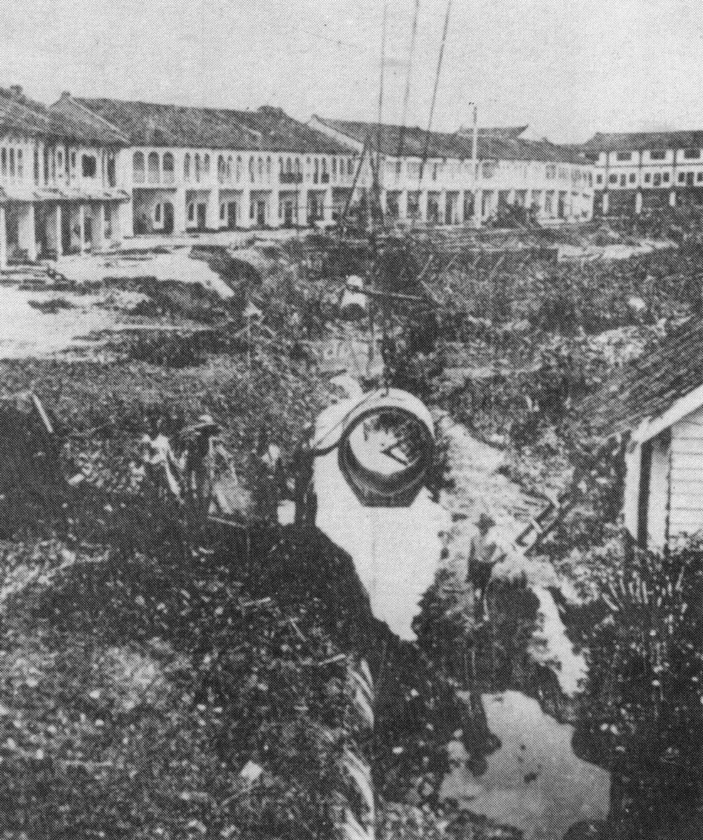
The newly completed shop houses on Hun Yeang Street, with the Market Street shop houses visible in the distance. In the foreground, reclamation works on Sungai Gartak were still underway (Photo: Kuching in Pictures 1841–1991 by Ho Ah Chon)
As for the shop houses on Hun Yeang Street, they were in fact built by Khoo Hun Yeang from Penang. Readers may refer to my earlier essay, The Khoo Family Footprints Left on Hun Yeang Street, for more on him. Khoo had already acquired revenue farms in Kuching by 1902, and the HunYeang Street shop houses were completed by 1907. On 5 April that year, The Straits Echo, published in Penang, reported that Khoo’s eldest son, Khoo Soo Jin, hosted a banquet for Kuching’s merchants and community leaders on 20 March (the seventh day of the second lunar month) in celebration of his father’s birthday. The banquet was held on the first floor of the Khoo family’s opium company on Hun Yeang Street. To mark the occasion, Cantonese and Teochew opera performances were staged nightly for seven consecutive days. At night, Hun Yeang Street glowed with lanterns and crowds thronged the brightly lit thoroughfare.
An issue of the Sarawak Gazette published on 4 January the same year also mentioned land reclamation works taking place at Hun Yeang Street, broadly matching the timeline above. A historical photograph from the period shows the newly completed shop houses, while reclamation work on Sungai Gartak was still visibly underway in front of them. The image was likely taken in 1906 or 1907.
In truth, from the 1880s onward, as development around the old bazaar beside the Sungai Kuching became increasingly saturated, the Rajah’s administration began turning its attention toward the Sungai Gartak area. As urban expansion gradually advanced, the river slowly disappeared. Beginning in the early twentieth century, reclamation projects steadily filled the waterway. Shop houses, the fire station, and even a power station arose upon newly created land. A 1917 map shows the once expansive Sungai Gartak reduced to little more than its river mouth. Even in 1921, the Sarawak Gazette still recorded reclamation work there, mainly for the construction of the power station.
Due to limited historical sources, it is impossible to determine exactly when Sungai Gartak was completely filled in, though it was likely sometime during the 1920s. Gartak Street, however, remains as a final marker preserving the memory of the vanished tributary.
Worth mentioning is that during drainage works around Hun Yeang Street in 2017, numerous late Qing-era ceramic fragments, pig bones, coconut shells, and glass objects were unearthed. Although the Sarawak Museum later assessed them as having limited material value, these finds nevertheless added a few fragmented yet precious clues to the forgotten history of Sungai Gartak.
Initially published in Sinchew Daily 星洲日报
Share this post
